Imagine a surveyor tasked with drawing an aerial view of a structure several miles long consisting of stone walls and natural features like slopes and cliffs. No camera can capture the entire structure from the ground and no higher viewpoint is possible. GPS isn’t available to determine position; neither is a tacheometer to measure distance. Yet the drawing must be to scale and accurately depict relationships between the structure’s functional elements.
A mapmaker today would be hard-pressed to produce this drawing. Yet Neolithic people—either the designers, builders or users of the mega structures today called “desert kites”—managed to engrave to-scale maps of them. And this occurred at least twice, 166 miles and a millennium apart. From 9,000 years ago until the past few centuries, humans built and used the vast structures depicted to hunt wildlife, such as gazelles, ibexes and Arabian oryxes. The hunters obtained food as well as hide, hair and horns for clothing, containers, tools and instruments.
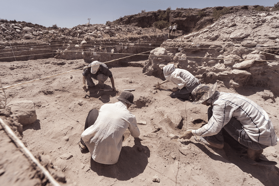
In modern times, walkers who chanced across the walls of a desert kite might not realize they had encountered a massive trap. Their purpose wasn’t apparent until aviators caught the first aerial views of them in the 1920s. But with the help of satellite imagery, scientists have now recorded more than 6,600 desert kites from Arabia to Uzbekistan, according to Rémy Crassard, researcher at the French National Centre for Scientific Research (CNRS). After scientists spent years excavating the structures but not finding many artifacts, the to-scale engravings have captivated them.
Curious why 3 million AECO professionals worldwide use Bluebeam to finish projects faster?

“These two major innovations, i.e., building what would become the largest structures in human history at that time and making cartographic representations to scale, are closely linked by a common point: mastering the three-dimensional perception of a space and translating it into an inscribed form of communication,” said the researchers in the open access journal PLOS ONE on May 17, 2023.
The architecture of a desert kite
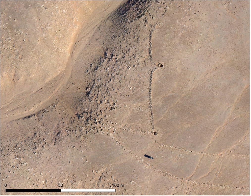
Desert kites were generally far from settled areas in environments that today are arid. They’re composed of driving lines—the tails that inspired the name “kite”—that run from hundreds of yards to more than three miles long. These lines converge on an enclosure with a median size of 2.5 acres. Up to 20 pits as deep as 13 feet surround the enclosure and ensnared the prey.

Along with construction that involves assembling stones of various sizes, kites often include topographic features such as convexities and slope breaks. The layout of the system within its environment is sophisticated, requiring planning and communication by the designers and builders. Given the size, organization, functionality and effort required, the authors said they see desert kites as fixed infrastructure of the landscape.
Building on historical representations
For at least 40,000 years, humans have reproduced images of their natural surroundings. And for many millennia, people have modified natural spaces. But few plans or maps existed until civilizations like those in Mesopotamia and Ancient Egypt could communicate in writing. What sets these desert kite engravings apart is that they’re not abstract representations but rather scaled depictions of a structure that actually exists.
“The notion of an aerial view forms the basis of Western cartography … and represents our exclusive conception of the territories that surround us,” said the paper’s authors. “This notion did not make sense in traditional pre-literate societies that represented spatial information symbolically.”
Crassard said the researchers believe the people who created the drawings had one of three purposes in mind: to share a plan to construct a desert kite; to enhance collective hunting strategies; or to provide a symbolic representation. This last possibility might reflect a desire to demonstrate and pass on knowledge of space, like the precise topographical criteria that kites are built on and around and what the space contains.
Strong similarity between engravings, nearby desert kites
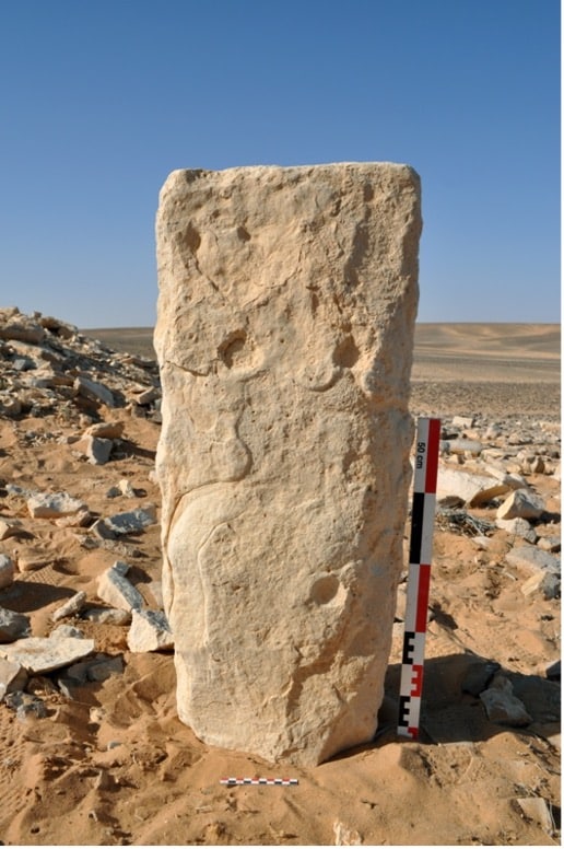
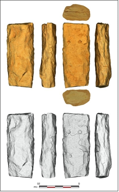
The carver of the engraved monolith found in Jibal al-Khashabiyeh, Jordan, used a rock tool on chalky limestone and multiple techniques, including fine incisions and pecking, to show a bird’s-eye view of the desert kite.


The engraving shows curving, converging lines about 16 inches in length, leading to a carved star-shaped enclosure approximately 10 inches in diameter. Around the enclosure, eight circular cupules ranging from 1 to 2.5 inches in diameter form the pits. Symbols, including chevrons, represent topography like a slope break or perhaps where a hunter would drive animals into the enclosure.
The researchers used computer-based verification to determine the degree of similarity between the engravings and nearby kite structures. The enclosure is a key focus, defined by its shape, the angles with the driving lines and the number of pits. In Jordan, the kites most similar to the engraving scored 75.90% (10 miles away) and 73.52% (less than a mile away). The drawings use a scale of approximately 1:425 and are in keeping with cardinal directions.
The shape, layout and proportions of the engraving shape fit well with top-view drawings of the remains of nearby kites. Comparable to-scale plans can be found only thousands of years later during the third and second millennia BC in Mesopotamia.
“What this discovery shows is that these structures would have been made by a system of calculation,” Crassard explained. “This calculation in the field has been transposed then in a smaller 2D surface. So this shows a conceptualization of space that has not been seen before in archaeology at such old sites.”
The evolution of human spatial perception
Transposing a mental picture of a structure not possible to see as a whole onto a small two-dimensional surface is a milestone of intelligent behavior acquired progressively from the early stages of human evolution, the authors emphasized.
Moreover, the desert kites themselves are the earliest stone-built constructions at such a large scale that archaeologists have found to date. Given the collaboration needed for a successful hunt, communicating spatial information by means of a realistic representation of them would have been essential to achieve the common goal.
Together, the kites and engravings shed new light on the evolution of human discernment of space, communication and communal activities in ancient times, and have far-reaching consequences for understanding the evolution of human cognition.


